
Mingshui Fm
Type Locality and Naming
Songliao Basin. The Mingshui Formation was erected by the Comprehensive Geological Brigade under the Songliao Bureau of Petroleum Exploration in 1960. The section for the designation is in the Mingshui County of Suihua, Heilongjiang (47°2′N; 125°8′E). The reference section is at No.ku-3 of the Monggol Autonomous County of Dorbod of Heilongjiang. Uppermost formation (7 of 7) in the Songhuajiang Gr.
Lithology and Thickness
The Mingshui Formation is represented by a set of sandstone and mudstone, which is divided in ascending order into two members. First member is built up by grayish green and grayish brown sandstone, sandy mudstone and black mudstone, constituting two normal cycles, of which the upper part is built up by black mudstone, being regarded as a marker bed for regional correlation. The lower part of the Second member is built up by grayish white siltstone and fine sandstone and brownish red and grayish green mudstone, while the upper part is brown red mudstone, gray and grayish white gravel-bearing sandstone, fine sandstone and clayey siltstone. The formation is 233 m thick.
Relationships and Distribution
Lower contact
The base of the formation marked by grayish green sandstone lies conformably on the variegated mudstone of the Sifangtai Fm.
Upper contact
Its top unconformably underlies the Paleogene Yian Fm.
Regional extent
The present formation is exposed on the surface on both banks of the Keyin river near Sifangtai of the Suihua City, Heilongjiang. It is distributed throughout Heilongjiang, except in the Nongan area of east Heilongjiang, and is best developed in the Dorbod County and the Gulong area of Heilongjiang. It is 418-496 m in thickness and 100-300 m in general. It decreases in thickness from the center towards north and west, and in the Anda-Maoxing area of the central part, the first member is missing. The second member covers a smaller area than the first member and is only limited to the area south of Yian-Mingshui, dominated by sandstone and mudstone with calcareous sandstone and clayey conglomerate. In the west and north parts there appear grit and conglomerate, dominated by gray black and gray green color in the western part and brown red, brick red and gray green color in the northern part. In Jilin it is 100-200 m thick to the west of the line linking Daan-Rangzijing-Changling of the Changling area; up to 617 m at maximum in the Heidimiao-Changling area, and becomes thinner towards both sides, generally measuring 100-200 m in thickness in the Baicheng area. Generally it tends to be thick in the east and thin in the west and is missing in the area west of Zhenlai-Sheli-Taipingchuan.
GeoJSON
Fossils
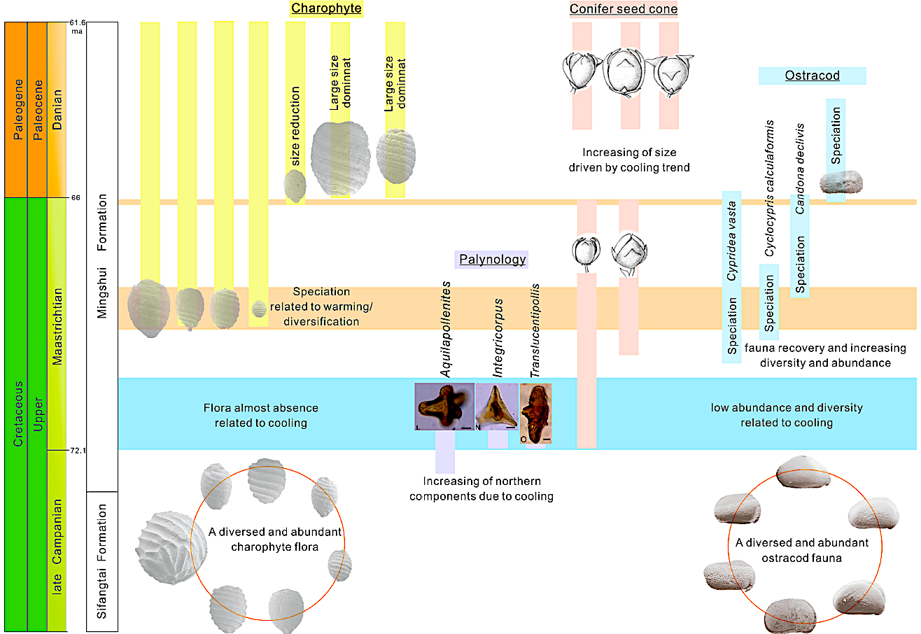
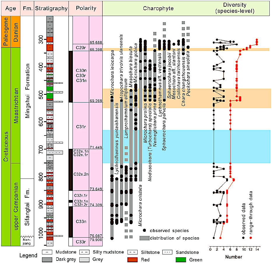
The formation yields charophyte flora Atopochara ulanensis-Hornichara anguangensis, Atopochara ulanensi, Hornichara prolixa-Gobichara deserta and Grovesichara changzhouensis-Neochara sinuolata; ostracods Talicypridea amoena, Cypridea apiculata, C. tera; bivalves Pseudohyria aff. gobiensis, Protelliptio (Plestelliptio) sungarianus; down the borehole No.qi-6 estheria Daxingestheria distincta; down the borehole gan-2 and gan-3, sporopollen grains represented by the Laevigatosporites-Aquilapollenites- Wodehouseria assemblage.
[Figure: Distribution of microfossil groups in Mingshui Formation of Songliao basin
(revised from Li et al., 2021)
[Figure: Mingshui Formation and Cretaceous-Paleogene boundary in Songliao basin with occurrence of charophytes (revised from Li et al., 2021)]
Age
Depositional setting
It is built up by a set of shallow light lacustrine deposition.
Additional Information